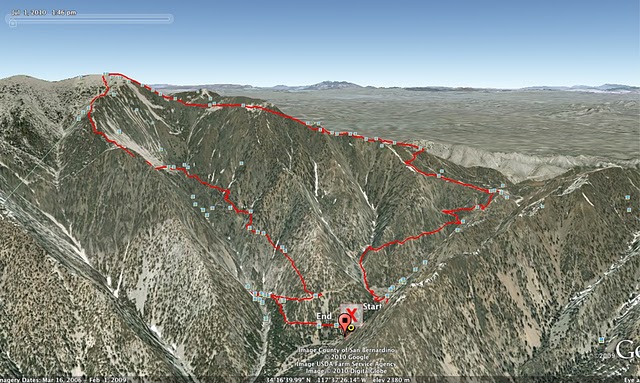
I’ve been wanting to hike to the top of Mt Baldy (the common name for Mt. San Antonio). About a month ago, I pulled something in my left knee. I’ve been recovering by running on the street, so I haven’t been trail running in at least a month. I was really wanting to get out on a trail so hiking Mt Baldy seemed like a good excuse and a way to go a little easier on my knee.
Driving from Riverside to the trailhead, I didn’t realize how far back the canyon goes to get to the town of Mt Baldy which is a neat little town. I stopped in town at the Visitors Center to buy an Adventure Pass to park in the National Forest which was $30 for the year. I drove a little further and parked at Manker Flats which is just a little short of the ski area and the most popular starting point for hiking the peak.
The trail starts at 6,100ft going up a paved road (behind a gate) which after about 1/2 mile, you reach San Antonio Falls. It’s not a huge waterfall, but it is quite scenic falling over 3 tiers with quite a bit of water, but not so strong that you can’t walk into it without falling. I was planning on hiking this as a loop, so too bad it wasn’t at the end which would be a nice way to cool off.
From the falls, the trail turns into a dirt road, which after 1/3 mile, you have to turn off onto a small single track trail off to the left. It’s unmarked and easily missed if you aren’t on the lookout for it. From here, the trail starts heading up quickly along a mostly shaded trail with views back into San Antonio Canyon where the falls are. I didn’t see many other hikers on the trail (not surprising for a Thursday), but did pass a group of 3 people with two dogs who seemed to be enjoying the trail. Around 2.5 miles, you pass a ski hut built by the Sierra Club and start to head across Baldy Bowl and up to a ridge line which climbs even steeper towards the top.
At 4.5 miles I reached the top of Mt Baldy 10,064 feet. While not the highest peak in Southern California, the views up here are amazing and well worth the hike. I could see San Gorgonio (highest in SoCal), San Jacinto (near Palm Springs), Santiago Peak and beyond over Orange County and even the ocean.
Heading down, I could have headed back the way I came but I’d rather make a loop of it, so I headed down the eastern side of the peak via Devil’s Backbone trail. The start was just a huge scree field which I slipped my way down. Crossing the ridge is quite an exciting part of the hike as at some spots, the trail is just a few feet wide with extremely steep slopes falling off both sides down several hundred feet, slipping off the trail here make for quite a bad fall, but the views looking over both sides was amazing. At about 7 miles, you reach the Mt Baldy ski area after which you take the dirt access road back down to the Manker Flats parking area.
Round trip, the hike was 10 miles, taking me a little over 4 hours and a 4,000 ft elevation gain.


