find me at:
Twitter Facebook Google+ RSS
Strava Activity

Entries in waterfall (12)

Friday
Nov212014

Eagle Creek in a Heavy Rainfall

Well we are clearly into the rainy season in the Pacific Northwest.  What I had been able to trail run just a few days earlier was nearly impassible on this day.  Small trickling streams crossing the trail were transformed into raging, waist deep, scary, fast moving flows.  Here’s a photo from the same place with much less water.

Find it here:  45°37’22” N;  121°53’42” W

Friday
Jan032014

oneonta gorge

I don’t think I’ll ever get tired of going to this place, Oneonta Gorge is just too amazing!

Thursday
Jan022014

frozen

It was unusually cold here in mid-December, and I was sitting in my office at work when I got a text from my neighbor saying that Multnomah Falls had frozen over!  I did a quick web search and it looked like this didn’t happen very often so I went out early the next morning at sunrise to check it out and this is what I found.  Pretty cool!

Tuesday
Dec242013

punchbowl falls

This is another one of those places in the Columbia River Gorge that makes it so amazing.   Punchbowl Falls is just an easy couple mile hike in from the trailhead.  The falls come spilling out into this “bowl” which is flanked by these really neat granite walls covered with ferns, moss, etc.  At times, it can be quite busy here by not many people walk out into the water (cold most of the year) or if you just wait a bit, eventually you’ll have a people free moment to get a nice photo.  There are several waterfalls along this trail and if you keep going, about mile 6 is a 250ft waterfall with a tunnel going right behind it halfway to the top!
Thursday
Nov072013

the mystery of oneonta gorge

This is my favorite place in the Columbia River Gorge and one of the most amazing and beautiful places I have ever been.  It’s one of those places that you lose time in as you immerse yourself in the surroundings.  I love the way the basalt walls of the gorge tilt in from different angles and when it is raining, little waterfalls stream in from the sides.  It is truly beautiful and amazing.
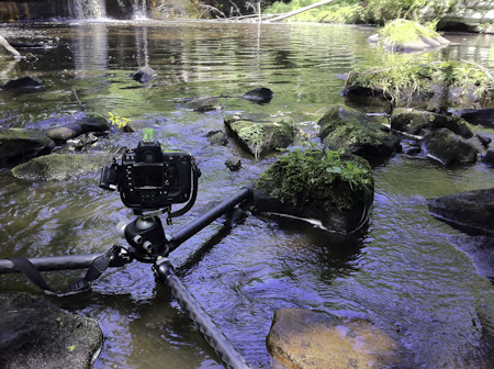
I used a Lee Big Stopper 10 stop ND filter to make a 3 minute exposure to smooth out the water and give it that blue cast.
Getting there - driving to the entrance, it looks like little more than a small creek with a road crossing it.  Even walking down to the creek you never really get a sense for what could be ahead.  You have to be prepared to get wet and walk up through the creek to a giant log jamb at the opening to the gorge (just a few hundred feet form the road) and then carefully pick your way up and climbing over the log jamb to get to the other side (it’s about 15 feet high and 50 feet long).  It can be really dangerous when wet and you’d slip and break an ankle or fall into the deep water below.   (I put on Kahtoola Microspikes when I’m going here so I don’t slip).  On summer days, you might be able to actually get into the creek on the other side but watch out after a rain fall as the water just past the log jamb is 10ft or more deep with a strong current.  If you can make it all the way up the creek (you’ll have to swim some spots) there is a neat hidden waterfall waiting for you at the end.
Monday
Nov042013

breaking light at wahclella falls


This amazing waterfall is just an easy one mile hike from a small parking lot near the Bonneville Dam in the Columbia River Gorge.  Anne and Gus were along for this hike and Gus hiked nearly the whole way by himself.  He does really good hiking for a 22mo old!

Just as we got to the falls, the fog started to break and the sun came streaming out through the trees at the top. There were so many great pictures from that morning, it was ahrd to pick one to post today!  I’m sure there will be more in the future :) 

Find it here:  45°37’6” N;  121°57’6” W

Saturday
Sep032011

the hidden falls

well, it’s not quite so secret since these falls are clearly marked on the map as Wolf Creek Falls in Banning State Park, MN.  When heading out here, I never expected these falls to have this great overhang covered with moss and lichen.  I had to get way up under here to get this neat angle.

This was also my first trip trying out my new Spot locator device.  You can read about it at the link if you haven’t seen these before and I will say I was really happy with it.  Small, and never got in the way clipped to my belt, it kept an accurate track of where I was which I posted a “live” map now on my website header.  Pretty cool!

Find it here:  46°8’47” N;  92°51’39” W

Saturday
Aug272011

a small creek flows here

Driving along CA-41 (Wawona Hwy) in Yosemite, you cross several small creeks that you really wouldn’t otherwise notice except for the small brown signs on the side of the road. Alder Creek is one of those and this is just a few hundred feet down from the road. If you are coming in through from the Oakhurst side entrance, be on the lookout for it a bit before you get to the Wawona tunnel. Whether you go up or down the creek from the road, you won’t be disappointed.

Find it here:  37°34’47” N;  119°40’43” W


Friday
Aug192011

not yet swept away

Taken just below Wolf Creek Falls in Banning State Park, MN.  It’s a neat little park roughly 90 mi north of Minneapolis.  Just a 1/2mi walk to the creek and falls, it feels very secluded, with growth right up to and over the water.  While up on the falls, I noticed these yellow flowers just down stream so I made my way down there quickly to capture them before they got swept down the creek.

Find it here:  46°8’48” N;  92°51’40” W


By the way, here is a picture I took while getting this shot:

Monday
Aug152011

the long fall


It’s been a while since I’ve gotten around to adding a new post here.  You know, life/work (mostly work) get in the way.                                                                        
This is the first photo I’m uploading from our trip to Yosemite.  While the weather was beautiful, it wasn’t really nice for taking pictures - there didn’t seem to be a cloud in the sky for the entire time we were up in the Sierras, not even a hint of those great afternoon thunderstorms that seem to build there.  Anyway, any trip to Yosemite is a great one and what’s a trip to Yosemite without a stop at Glacier Point.  This view of Upper Yosemite Falls from across the valley and used a 10 stop ND filter to smooth out the water.  Often at this time in the year, the falls (especially this one) have slowed to a trickle but with all the snowpack from the season, they were still flowing strong.
Wednesday
Jul202011

Gooseberry Falls

This area is about an hour north of of Duluth on the shore of Lake Superior. Since the state of Minnesota was closed, this park area was closed too, but you could just park on the road and it was a short walk to the falls.  I never realized that this part of Minnesota had so many cliffs and bluffs - I’m looking forward to exploring this part of the state more now that I’m living here.

Find it here:  47°8’34” N;  91°28’3” W

Saturday
Aug142010

The Old Rustic Mill


Took this picture on our last trip to Wisconsin.  This place used to be a feed mill, then a tavern, restaurant, closed for a while, then reopened as a restaurant in July.  Its on Hwy 54 just south of Black River Falls and just north of our property.  From the road, you wouldn’t even know there was a small waterfall behind the building and even when walking behind the building, at first glance you wouldn’t notice the old sluice pipe left over from the days when this old place had a waterwheel.  The waterfall was neat, but this old pipe was even neater, taking on a SciFi-esque steampunk character giving hint to some post-apocalyptic world where nature is taking back.

UPDATE -Fall 2011  it is now burned to the ground!

Find this here:  44° 16’ 12” N;   90° 52’ 29” W