Saturday
Mar262011
are you with me
Posted on  Saturday, March 26, 2011
A lone pair of trees near Benton Crossing Rd in the Eastern Sierras.
Find it here: 37°38’7” N; 118°48’38” W
A lone pair of trees near Benton Crossing Rd in the Eastern Sierras.
Find it here: 37°38’7” N; 118°48’38” W

 Wow, lots of traveling this weekend. Seeing that we might soon be leaving California, I wanted to spend a weekend traveling up the coast to San Francisco so we (Anne, Astro, and Orion and I) started off by driving up to Monterey from Riverside on Thursday night.
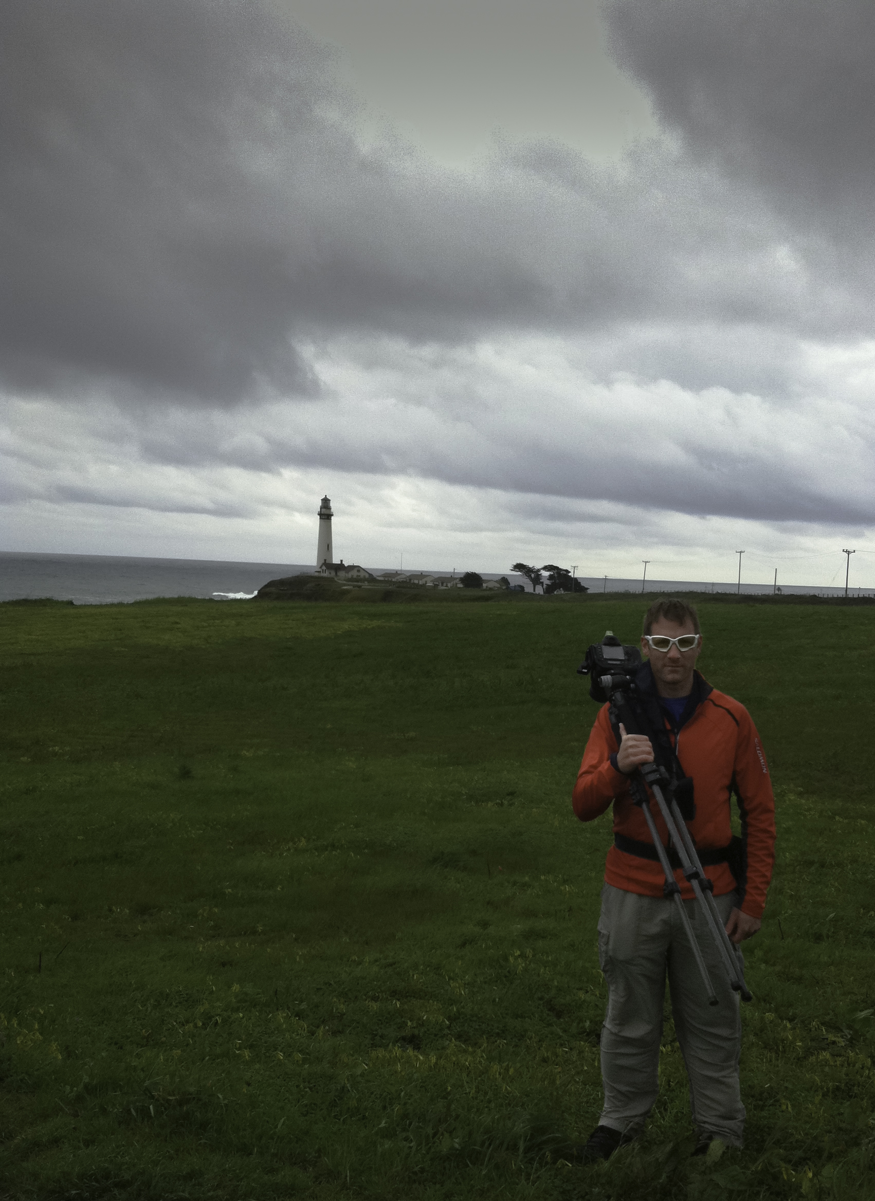
The first stop on Friday was the Apple Store in Monterey where Anne was finally able to find an iPad 2 in stock - score! We then took the 17 Mile Drive south out of Monterey and down the coast through Pebble Beach (the golf resort). I wasn’t happy having to pay the $9.50 fee to drive on the road and the start of the drive wasn’t very impressive, passing some likely expensive coastal homes and driving along the golf courses that follow the rocky shore. Much of the first half of the drive is not anything that you wouldn’t see anywhere else north or south of this area and definitely not worth $9.50 to see, but the second half is more impressive with the crown jewel being the Lone Cyprus tree which is definitely worth a stop to see and photograph. While it was extremely windy, the rain held off until we headed back to Monterey and north up the coast towards San Francisco. Driving through and past Santa Cruz, the coastal scenery is amazing, green as could be rolling hills, bluffs and cliffs coming right up out of the water and small towns leading up to the metro area. Along the way, we stopped at the Pigeon Point Lighthouse to take some pictures and let Astro and Orion out. By the time we got to San Francisco, the rain had started falling pretty heavily and really wouldn’t stop for the next two days while we stayed at the Marina Motel on Lombard St. It was a very small 1 room “apartment” that was a tight fit, but a good rate and location.
Saturday morning, we got up and went for a run, heading towards the bay, then up the back to the Golden Gate Bridge. Getting to the bridge only was 2.5 miles, so we headed up onto and across the bridge to the other side and back during which it really started raining and we got completely soaked - but it was still lots of fun! I was surprised to see so many other runners out there in the rain, something you never see in southern CA - nice to see other people aren’t afraid of getting a little wet! Lunch was a cupcake from Kara’s Cupcakes (wonderful little shop in the Marina area) and we spent the rest of the afternoon driving around sight-seeing around the SF area. At sunset, I tried to get some photos in of the Golden Gate Bridge from the Headlands park, but the weather just wouldn’t cooperate. The wind really never let up and it was raining pretty hard, blowing right up the face of the hill and into the direction of my camera. I really wasn’t succesful, my lens just got covered with water and the shot never turned out good.
Sunday, we were headed back to Riverside, but first stopped at the Headlands park to see if the weather would cooperate and I could get a few shots of the Golden Gate Bridge. It was raining on the way there (pretty heavy), but just as we pulled up to the pull out area, it let up for about 10 minutes and I was able to get in some photos. It was actually really neat out, with dark, heavy clouds around the city, fog around the bridge, and green and wet hillsides. I’m looking forward to processing these pictures soon. Our drive back was filled with nothing but more rain except for the insanely huge snow flakes that were falling near Tehachapi when we got back south.
California the name says it all….
Find it here: 37°41’48” N; 118°45’35” W
This was taken on a beautiful morning in the Eastern Sierras near Benton Crossing Road on the Owens River. It’s really neat the way the wind can blow patterns into snow and sand. The low angle of the early morning sun accentuated texture.
Find it here: 37°41’57” N; 118°45’55” W

Wow, it’s been way too long since I posted anything or any photos. It’s been a busy (when isn’t it) month at work, life, ect. I guess you can always make excuses for why “it” didn’t happen. Since my last post, I really haven’t been out taking many photos - I think I have been not feeling very creative to tell you the truth. I did go to Florida on a trip with my mom to see her sister and a cousin from France and that was a fun trip though.
Yeah, lots going on. I have some cool news that I’ll be able to share and show sometime in April. Also have had some really some really big life/career decisions to make in the last couple weeks. I was offered a great promotional opportunity in SoCal but it would have meant relocating closer to Los Angeles. I was sold on the idea but after some deep thought I realized that I really needed to re-evaluate what was important. Then, that night I came across this great post by photographer David duChemin - Life is Short, and it made me wonder why I was struggling with this decision. It’s really worth reading if you have a moment, I promise you won’t be disappointed.
After reading that, it seemed like the obvious choice - we’ve been in California long enough and it’s time to head back to the Midwest to be closer to family and our property there. What that means is that we’ll be moving by the end of summer if not sooner as we work out the details. I’m pretty excited to start this next phase and see what it brings…
Isn’t it strange how we make life much more complicated than it needs to be? I’ve actually had quite a few pictures ready to post recently but just didn’t feel like sitting down and doing that. I’ve been in the habit of naming my pictures when I’m done so for this one, that happened a couple months ago. When I sat down tonight to finally getting around to posting a photo, I had a completely different one in mind, but then browsing my catalog, none felt more appropriate for this post than this one which I named “taking flight” as we get ready to migrate east.
This was taken at the Salton Sea near the North Shore Yacht Club. What a strange and surreal place - a collection of abandoned dreams of seaside resorts and abandoned buildings, boats, and trailers. In this area, the “beach” isn’t composed of sand, but rather crushed shells and the rotting and mummified carcasses of fish washed ashore. In the winter, you can see the snow capped peaks near Big Bear way off in the distance which adds to the feeling of this being a post apocalyptic world.
Find it here: 33°31’13” N; 115°56’18” W

Went for a 12mi trail run in the Santa Rosa Plateau park in the Temecula/Murrieta area and it was one of the most beautiful days that I have been there for. The grass was green and there were cool grey clouds and light rain on and off. I was on Monument Hill trail when I saw this tree and couldn’t pass up the chance to take a picture. If you live in the area and have never been here, you’re missing out!
On a side note, this was the longest run I gone for in my Vibram Five Finger shoes and after three weeks, I’m really liking them. The transition from regular shoes wasn’t bad at all and I only got a small blister under one toe which is long gone. Running on the trail is more fun and it is really cool to feel the roll and curves under your feet. These are the only shoes I’ve been running in for the past three weeks and I really don’t feel the need to go back for either road or trail running. I’m registered to run the La Jolla Half Marathon in April and plan to race in these too.
taken with my iPhone.
Find it here: 33°31’35” N; 117°15’1” W


This photo came from inside one of the abandoned out buildings that I was poking through while down in San Diego for the terrier races. I was in storage building filled with junk but a smaller portion was walled off in the back. I went outside, ducked under a half closed door and found this fire hose piled in a corner of an otherwise empty room.
Find it here: 33°14’7” N; 117°1’23” W

Do you ever really notice how tall and narrow bridges are when driving over them? I don’t. Sure, you can look out over the sides and to the periphery but while you’re in a car, I don’t think you really ever notice just how “exposed” you really are. I only really notice this when walking out onto a bridge, getting halfway out and feeling the railing coming up waist high then looking down and back to the beginning and end - you get that feeling of Wow, this is way up/out here! This is the Sheepeater Canyon Bridge in Yellowstone near Mammoth Hot Springs, it made me feel this way.
Find it here: 44°57’32” N; 110°40’50” W

;) Today was a full day! We started out this morning heading down to San Diego before 7am to go to a South Coast Jack Russell Terrier Club “fun day” with practice terrier races. Anne wanted to have Astro try the racing event since Astro loves to run with us (she usually runs at least 4 miles and sometimes up to 9 miles). It was being held at a park in Valley Center and we got there just as they were setting up. The idea is that the terriers race out of the gate chasing a lure pulled at high speed by a cable down a 200ft course jumping over four or five hurdles 1ft high along the way. Since we were some of the first people to arrive, we helped set up the course. The organizers couldn’t have been nicer or more welcoming and when everyone began arriving with their terriers, it was funny to see so many of these high energy dogs all together in the same place.
Today was a full day! We started out this morning heading down to San Diego before 7am to go to a South Coast Jack Russell Terrier Club “fun day” with practice terrier races. Anne wanted to have Astro try the racing event since Astro loves to run with us (she usually runs at least 4 miles and sometimes up to 9 miles). It was being held at a park in Valley Center and we got there just as they were setting up. The idea is that the terriers race out of the gate chasing a lure pulled at high speed by a cable down a 200ft course jumping over four or five hurdles 1ft high along the way. Since we were some of the first people to arrive, we helped set up the course. The organizers couldn’t have been nicer or more welcoming and when everyone began arriving with their terriers, it was funny to see so many of these high energy dogs all together in the same place.;)
On her first try, Astro was a little confused and didn’t really like wearing the muzzle but after she realized all the other dogs were racing too, she was motived and did pretty good probably running about 10-12 heats. Orion in the other hand, was more interested in the other dogs than actually running himself. He made a couple attempts, and made it down the course once, spending his other two tries working on getting his muzzle off.
About half way through the afternoon, I walked over to explore some abandoned buildings in the field next door. There was a cluster of 5-6 buildings that looked like they used to be a mix of old garages and field offices not used in a long time. I made some attempts at capturing some brackets for HDR but didn’t bring my tripod and with the indoor light I might have had too much camera shake - we’ll see…;)
After the races, we drove down to Torrey Pines State Beach to get some running in ourselves. The weather was great (mid-50’s) with a good breeze and recent rains leaving the sandy trail just damp enough to firm up. This was my first trail run in my new Vibram Five Finger shoes which a got a couple days ago so I was really interested to see how they worked. We started at the lower parking lot, running up the hill then around the partially closed Guy Fleming loop, back to the road and up to the top and down the Razor Point trail to just above Flat Rock, back up to the road via Broken Hill and South Fork trails, then back down the road, down the big hill to the parking lot. The Vibrams were awesome. My legs felt great and I was rally cool to feel every bump and curve in the trail. I was able to corner and bank around curves easier and with more confidence since your feet don’t slide out as easily. So far I’ve run a few runs on streets as well and considering how the Vibrams have worked both on and off the trail, I think they are going to be my only running shoe for a while.
Yellowstone has to be one of the neatest places in the US. You could spend days exploring all there is to see here not to mention having Teton National Park right next door. This is by far, my favorite place to take a road trip. Isn’t it strange how so many people travel outside our country to see “beautiful places” and haven’t even explored their own backyard yet?
This is a photo of the Emerald Pool at Black Sand Geyser Basin.
Find it here: 44°27’40” N; 110°51’18” W

While walking down through Santa Monica, this panel and hydrant caught my eye.
Find it here: 34°0’57” N 118°29’39” W


It’s obvious where I took this photo. We were down in Santa Monica to run the Malibu International Marathon the next morning. Its quite an interesting here with the mix of tourists, hippies, homeless, and well off people all in the same place.
Find this here: 34° 0’ 41” N; 118° 29’ 42” W

 While walking around downtown Minneapolis, I came across this statue of Mary Tyler Moore at the corner of 7th and Nicollet Mall. It was cold and just started to snow and there was nobody around even though it was only 6pm. Very strange, I thought people in Minneapolis didn’t mind the cold.
Find this here: 33°57’21” N 117°19’7” W
I took this photo on the first day of our trip to Jackson Wyoming this summer. This is very near the southern entrance to Teton National Park one of the most beautiful places I have ever been - you can’t go wrong taking a picture in any direction. This one is just outside a horse pasture at one of the first pull outs into the park.
Find this here: 43° 48’ 36” N; 110° 31’ 40” W

![]() Night three in Minneapolis. I couldn’t come to town without photographing the reason I came here - Target HQ in downtown. The colors at the top of the building are really cool - the only thing that would make it cooler is a giant King Kong sized Bullseye dog climbing up the top side!
Night three in Minneapolis. I couldn’t come to town without photographing the reason I came here - Target HQ in downtown. The colors at the top of the building are really cool - the only thing that would make it cooler is a giant King Kong sized Bullseye dog climbing up the top side!
Find this here: 44°58’24” N 93°16’32” W
Night two in Minneapolis. It was cold and snowing tonight but I was set on going out. I headed out from my hotel walking around downtown until I came across the church. The city lights were lighting up the sky in this neat orange glow which made a great backdrop for the church.
Find this here: 44° 58’ 19” N; 93° 16’ 36” W

Minnesota 
