find me at:
Twitter Facebook Google+ RSS
Strava Activity

Monday
Nov292010

Down the Skyway

Taken in the Minneapolis Skyway conecting the Graves 601 hotel to Target Center.This is only my second time to downtown MSP and I’m fascinated by how these Skyways go all over downtown like big hamster Habitrails.

Find this here:  44°58’46” N 93°16’31” W

Wednesday
Nov102010

Get Bent!

Is this one crazy tree or what?  While driving in to Coulter Bay to see Jackson Lake in Wyoming, this tree caught my eye a ways down an empty parking lot.  It was so unique that I had to stop and take a picture.  I’ve seen trees bent before for landscaping reasons (with cables, etc) but this one was just in some random part of a parking lot in the middle of the “island” strip that ran between two lanes.  I took this shot from a very low angle and the lens I used is so wide, it lets you get up real close.

Find this here:  43°54’15” N 110°38’39” W

Saturday
Nov062010

Teton Pastures

The whole Jackson, Wyoming, Teton National Park, Yellowstone area is just amazing. One scenic view after another. If you’ve never taken the time to visit this part of our country, you’ve done yourself a disservice. There is days of exploring and learning to do here and beauty in every direction you look. It’s almost impossible not to take a great picture no matter what season or weather. This picture was taken just as we entered Teton National Park on our way to Yellowstone. I think we started off pulling over into every little turnout (there are many) and reading the monuments, taking in the view. You can’t help but want to stop, but then after a bunch, we realized if we continued on with this, we’d never make it to Yellowstone!

If you want to see the exact spot where this picture was taken, I geotag all my pictures. You can click on the picture to get to my Flickr photostream which has a map or click this link here to get to a Google map look for the green arrow.

Find this here:  43°48’37” N;  110°31’40” W


Wednesday
Nov032010

Beach Day at the Edge of the World

Coulter Bay on Jackson Lake in Teton National Park. There was this really cool storm forming just west of the Tetons in Idaho. We were listening to an Idaho AM radio station broadcasting the emergency warning and hearing the lighting “pops” crackle through the radio. This beach is covered with these large flat/smooth stones thus the course look to it.  Just after taking this photo, it started to rain, one of those really cold summer mountain rains, it was awesome!

Find this here:  43°54’21” N; 110°38’51” W

Wednesday
Nov032010

Cool Autumn Day in Wisconsin

While at work today, an email popped up from Jim (the architect designing our Wisconsin home) who stopped by our site.  He sent us this picture standing at the top of the cliff looking west across the spot where the building will be sited.  It’s an awesome sunset and cool to think that this view will soon be from within our living room!  We didn’t expect Jim to be visiting the site, so this unexpected (but welcome) picture made that far off place seem like a reality again and made my day!

Monday
Oct042010

SR-71 Blackbird - one kickass jet

Here is a processed image from my trip to the March Airfield Museum in Moreno Valley, CA.  This is one kick ass jet!  It was one of the fastest manned jets ever flown which reached speeds of around Mach 3.5 (3.5x’s the speed of sound!) and flew at altitudes of 80,000 ft!  Amazingly, it was designed in the early 1960’s, first flown in 1964, and flew until 1998.  Makes you wonder what is being designed and flown now that we don’t know about…

Find this here:  33°52’59” N;  117°15’58” W

Saturday
Oct022010

Into the Wild Blue Yonder

We visited the March Air Field Museum today which is just five minutes from home. I drive past it once a week and have been wanting to stop there since it looks like they’ve add to their collection since the last time I was there a few years ago. I wanted to photograph some of the planes and today we are having some afternoon thunderstorms so it seemed like a great time to go. When we got there, the sun was still quite intense but cloud cover eventually moved in. They have a pretty good collection of planes, mostly outside - it’s amazing how much damage the sun and weather can do to the paint on these things.

Everyone there was extremely nice, one even took us into the restoration shop to see the machining and painting areas. Its hard to imagine flying some of these planes in combat or having to sit in one for hours as they made their way to a bombing target. Really makes you appreciate the relative “luxury” we have flying on the airlines we do today. I got some neat pictures of a SR-71 Blackbird, Soviet Migs, and a B-17 bomber which is what my grandfather was shot down in during WWII over Athens, Greece (then taken to the Stalag Luft I POW camp in Germany).

Sunday
Sep192010

Venice Beach - Harry Perry

Taken during my first trip to Venice Beach, CA. Surprisingly, after all the time I’ve lived in Southern California, I’ve never been there.  We went there to look at modern design homes spurred on by some pictures we saw in a home architecture book.  I had heard that this place was “eccentric”, but walking down the boardwalk was more so than I had expected. This is a photo of Harry Perry a local street performing musician on inline skates.


Find this here:  33°59’23” N 118°28’34” W


Friday
Aug272010

Lone Tree in Teton National Park

After spending two days at Grand Teton National Park this lone tree caught my eye just as we were leaving the park.  We had just finished a great trail run around Jenny Lake and went back to take a few more pictures.  While the Tetons are beautiful, I think this might be my favorite picture from the trip.

What is really cool is the ability to geotag your photos.  If you click here, you’ll see a green arrow  on Google Maps where I was standing and just to the east is the tree and its shadow.  Even cooler, is if you go into Street View, you can pan to the right and see the tree from the road.  Technology is amazing!!

To do this, I added a diGPS Pro to my Nikon D700 which stays connected all the time.  It’s just a small dongle that hangs from the neckstrap on a custom little 1” strap I made.  I haven’t noticed a drop in battery life and it only turns on when my camera is on.  There are other solutions to geotag photos, but they all either require you to find the location on a map after (on your computer) or the dongle records the location constantly then you have to match that up to your pictures afterwards (based on time) on your computer using special software.  With the diGPS, it writes the GPS data into the EXIF info of the picture when you take it so there is no fussing around afterwards.

Find this here:  43° 42’ 21” N;  110° 43’ 28” W


Sunday
Aug152010

Wyoming Highway Sunset

On our last drive from Wisconsin to we stopped to check out Devil’s Tower in Wyoming and then got back on I-90 westbound for Sheridan, WY.  Shortly after we go on I-90, the sun started to set with these neat clouds on the horizon.  There was very little traffic on the freeway so I was able to jump out in the middle of it and snap these (while Anne was freaking out a little since I was in the road).

Find this here:  44° 17’ 37” N; 105° 9’ 25” W

Saturday
Aug142010

The Old Rustic Mill


Took this picture on our last trip to Wisconsin.  This place used to be a feed mill, then a tavern, restaurant, closed for a while, then reopened as a restaurant in July.  Its on Hwy 54 just south of Black River Falls and just north of our property.  From the road, you wouldn’t even know there was a small waterfall behind the building and even when walking behind the building, at first glance you wouldn’t notice the old sluice pipe left over from the days when this old place had a waterwheel.  The waterfall was neat, but this old pipe was even neater, taking on a SciFi-esque steampunk character giving hint to some post-apocalyptic world where nature is taking back.

UPDATE -Fall 2011  it is now burned to the ground!

Find this here:  44° 16’ 12” N;   90° 52’ 29” W

Tuesday
Jul062010

Hike to top of Mt Baldy (Mt San Antonio)

I’ve been wanting to hike to the top of Mt Baldy (the common name for Mt. San Antonio). About a month ago, I pulled something in my left knee.  I’ve been recovering by running on the street, so I haven’t been trail running in at least a month.  I was really wanting to get out on a trail so hiking Mt Baldy seemed like a good excuse and a way to go a little easier on my knee.

Driving from Riverside to the trailhead, I didn’t realize how far back the canyon goes to get to the town of Mt Baldy which is a neat little town.  I stopped in town at the Visitors Center to buy an Adventure Pass to park in the National Forest which was $30 for the year.  I drove a little further and parked at Manker Flats which is just a little short of the ski area and the most popular starting point for hiking the peak.


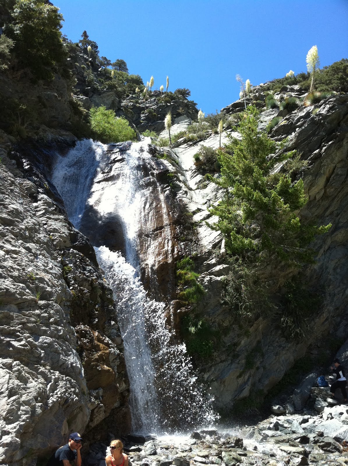
The trail starts at 6,100ft  going up a paved road (behind a gate) which after about 1/2 mile, you reach San Antonio Falls.  It’s not a huge waterfall, but it is quite scenic falling over 3 tiers with quite a bit of water, but not so strong that you can’t walk into it without falling.  I was planning on hiking this as a loop, so too bad it wasn’t at the end which would be a nice way to cool off.


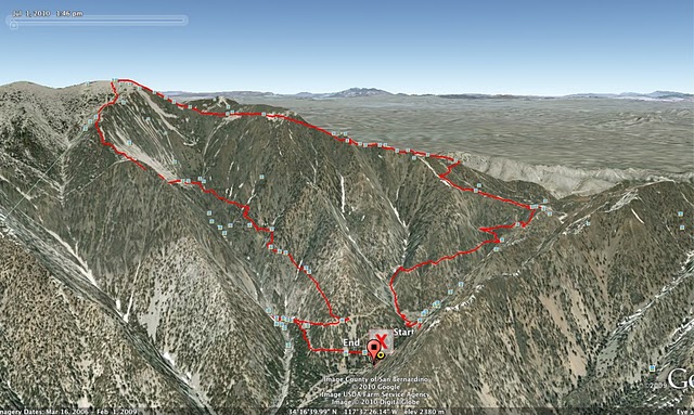
From the falls, the trail turns into a dirt road, which after 1/3 mile, you have to turn off onto a small single track trail off to the left.  It’s unmarked and easily missed if you aren’t on the lookout for it.  From here, the trail starts heading up quickly along a mostly shaded trail with views back into San Antonio Canyon where the falls are.  I didn’t see many other hikers on the trail (not surprising for a Thursday), but did pass a group of 3 people with two dogs who seemed to be enjoying the trail.  Around 2.5 miles, you pass a ski hut built by the Sierra Club and start to head across Baldy Bowl and up to a ridge line which climbs even steeper towards the top.
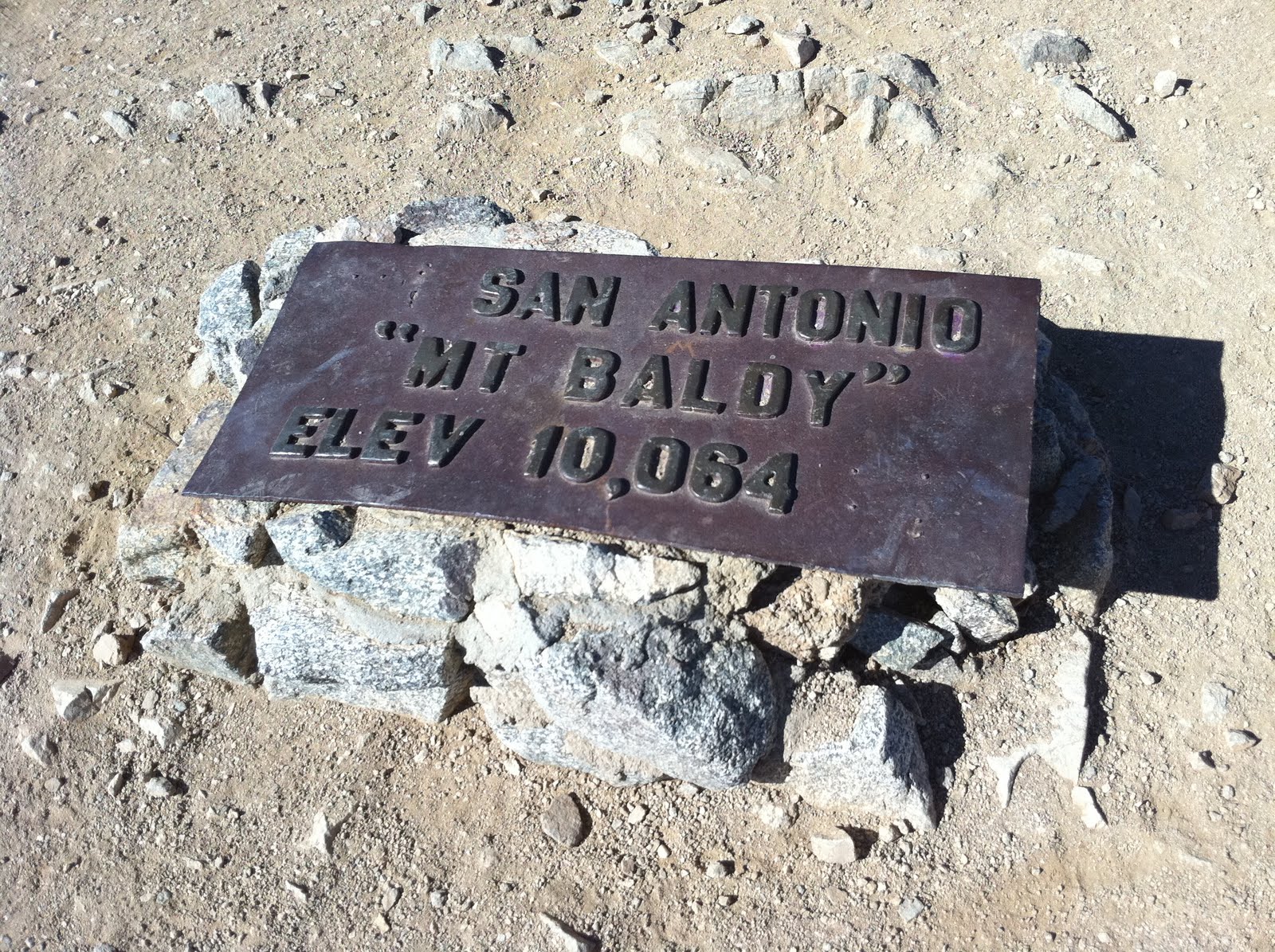
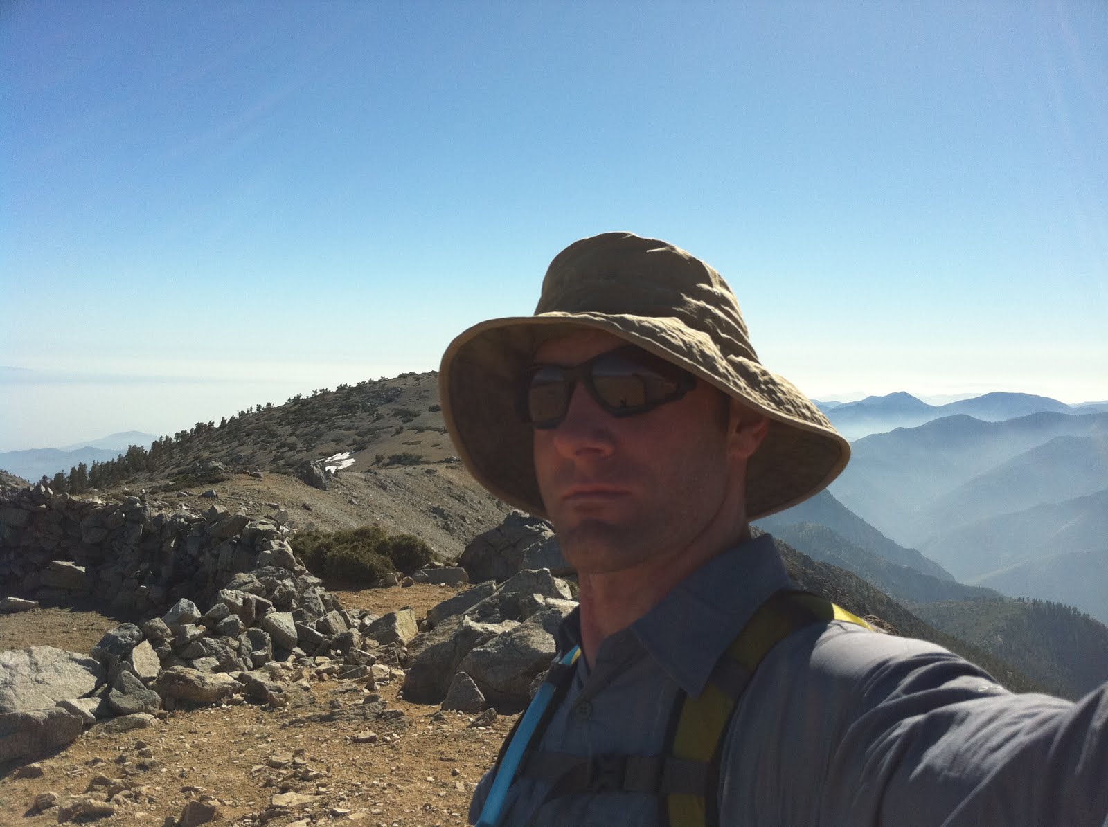
At 4.5 miles I reached the top of Mt Baldy 10,064 feet.  While not the highest peak in Southern California, the views up here are amazing and well worth the hike.  I could see San Gorgonio (highest in SoCal), San Jacinto (near Palm Springs), Santiago Peak and beyond over Orange County and even the ocean.


Heading down, I could have headed back the way I came but I’d rather make a loop of it, so I headed down the eastern side of the peak via Devil’s Backbone trail.  The start was just a huge scree field which I slipped my way down.  Crossing the ridge is quite an exciting part of the hike as at some spots, the trail is just a few feet wide with extremely steep slopes falling off both sides down several hundred feet, slipping off the trail here make for quite a bad fall, but the views looking over both sides was amazing.  At about 7 miles, you reach the Mt Baldy ski area after which you take the dirt access road back down to the Manker Flats parking area.


Round trip, the hike was 10 miles, taking me a little over 4 hours and a 4,000 ft elevation gain.   


Tuesday
Jun222010

Huntington Beach Pier

I’m not a beach person and don’t spend much time hanging out there (not even when I lived in San Diego) but I happened to be in Huntington Beach for a work meeting/dinner with Target at Duke’s on the start of the HB pier. We got done just before sunset and since I had my camera in the car, I grabbed it and headed down to the beach. The light just after sunset was really cool and not many people were on the beach because it was windy. I set my tripod up right at the edge of the water and took these pictures just before a larger wave almost washed my tripod and camera out. Nikon D300s and a Nikkor 14-24 lens.

Find this here:  33°39’23” N   118°0’17” W


Friday
Jun182010

New Picture of Orion

Took this picture of our puppy Orion earlier this week and wanted to share it.


- Posted from my iPad


Monday
May312010

Exciting Start to Memorial Day Weekend - Plan D

We didn't have anything planned for the holiday weekend (I don't like traveling during holidays) but it started off with an exciting email from Jim at GMK Architecture with his most recent design plans for our Wisconsin home.  This most recent plan is the result of the changes we discussed when we met at his Madison office back in April.  This is about the fourth version that we have gone through since November:


Plan A - initial plan, long and narrow, like a glassed in bridge extending out toward the cliff; 2 floors with a long "pier" like deck that went out toward the cliff
Plan B - long, going out towards the cliff but then turned back on itself with bedrooms on backside of house; 2 floors. This change was necessary after the results of the geotechnical engineering study showed we needed to stay 50ft back from the cliff.
Plan C - 3 floors w/ master bedroom on top which had a south facing angled huge skylight above the bed.
Plan D - the current one - a 2 floor version of B with a skylight like C which will run from just over our bed, south over the kitchen.  The master bedroom is set up so that it is open into the kitchen and living room so the view from all the windows in the living room and bedroom can be shared.  There is going to be a large pocket door and a pocket wall that we can move into place for privacy when guests are over.  Most of the living/dining/kitchen area is going to be floor-to-ceiling windows looking out towards the cliff.  The master bedroom window looks west out into a beautiful stand of poplar trees.


We were excitedly waiting to see this update and it did not diasappoint.  After spending a lot of time this weekend looking at the plans, there aren't many changes that we will want made other than moving a couple doors and maybe a window near the master bedroom.  I think this is the final design concept and now its on to working out the details.  As Jim goes on to work out the structural and building details, we've got a few things we need to work on as well:


Heating/Cooling - no forced air (i.e. duct work).  We'll have radiant heat in the floors and use a geothermal well system to heat and cool the house.  Anne is working out the early details of the geothermal system.  We will be on a well for water, we'll be drilling that anyway.
Photovoltaic system - we had an assessment done by a consultant and are waiting on the results of how efficient our site will be and how many panels we will need.
Electricity/Phone - need to figure out what is the best way to get it up to the top of the hill.  Our access road is 1/2 mile from the paved road (and power) to the house site.  It's not feasible to trench up the road, so we need to figure out how to go up the side of the hill.  I think we will also have a back-up generator in case.  Since our power will be coming down the road from a long single run either way on the highway, in the event that there is a big storm/ice storm, a generator would be a good idea.
Septic System - not really happy about this, but here is no sewer system in this area so we'll need a septic field or large holding tank.  We don;t have much flat land at the top of the hill, so the latter is probably the only choice we have.


We've set a goal to start construction in April/May 2012 to give us time to finish working out these details and hopefully to have it completed by December in 2012, just in time for the end of the world!

Monday
May172010

Joshua Tree National Park Astronomy


We spent last night out in Joshua Tree National Park with our telescope out under the stars.  We stayed in Cottonwood Springs campground where every campsite was taken by dark.  Even though it was full, the people camping there were generally quite and their fires weren’t too big.  The night was warm (55F), zero breeze, and one of the clearest skies we have had out there ever - the sky was very still, no twinkling stars.  We spent some time looking at Saturn, M13 Hercules Cluster, Veil Nebula, Sombrero Galaxy, cruising through various galaxies in Virgo, and a number of other Messier globular clusters.  Along with these, M51 the Whirlpool Galaxy, was the best we’ve ever seen it.  It was clearly visible even without averted vision and showed a lot of detail.   We also looked at M16 the Eagle Nebula - on several previous occasions, I’ve tried to see the Pillars of Creation region of the Eagle Nebula but had never been able to make them out before.  The Pillars are one of the early Hubble Space Telescope pictures that were publicly popular.  With a little searching, both Anne and I were able to see them which was really exciting!  Amazingly, the Pillars were actually destroyed around 6,000 years ago by a supernova, and we won’t see them destroyed for another 1,000 years or so, because M16 is 7,000 light years away.
Milky Way picture - 30 second exposure looking southeast toward Sagittarius (you can see it if you look closely).


Monday
Apr192010

The Holy Family Shrine - on our drive to Wisconsin


Find this here: 41.075334 N,-96.278582 W

Last fall, on our driving trip from California to Wisconsin, we saw what we thought was a tall, glass” barn” on a hill off the south side of I-80 just west of Omaha,  Nebraska.  
It caught our eye, because Jim (our architect) likes barns and at some point in time talked about how it would be neat to build a glass “cube” type home inside an old barn so you could see the light coming in through the old boards and cracks. When we got home, I tried searching for pictures of it on the internet but couldn’t find any.  I thought for sure that if someone built a glass “barn”, that I’d be able to find some kind of reference to it.
It turns out that we were making the same drive last week, going to Wisconsin to meet with Jim about our house plans and work on a few other things.  As we were driving down I-80, I was determined to be on the lookout for the glass barn so I could take a picture of it for Jim.  Funny, because we only drove by it once before, but I could tell when we were getting near and just as it came into view, we pulled over and I took the picture above.
I zoomed in to the “barn” with a 300mm telezoom lens and I could see pews as I realized that it was a church of some type.  I jumped back in the car to look at the map to see how we could drive over there.   We got off the freeway at the next exit and drove down a gravel road past a couple farms to find a sign for the Holy Family Shrine.  From the parking area, you could only see the roof of the glass structure, rather there was only a walkway that led to a glass doorway into the side of a hill.  The door opened into a cool, cave-like room that had a water feature hanging from a skylight which dripped into a pond/pool in the center of the room.  This part of the shrine was supposed to represent Jesus’s burial chamber. From the pool, a small creek ran out towards another doorway outside that lead down a pathway to the glass shrine.  Along the walls, there is a great set of storyboard that tells about the planning and construction of the Shrine which you can find here at their website.
 
We walked out this doorway into a beautiful courtyard with colorful trees and flowers with the glass part of the Shrine at then end of the walkway.  The construction details were amazing and the site was beautiful.  It occupied one of the highest hills in the area so it had a beautiful view of the surrounding landscape.  The structure was made mostly of wood and glass with some steel supports that blended in well.  The foundation looked to be made of flagstone, which underneath hid the geothermal heating and cooling system.
The inside was just as amazing as the outside.  Upon entering, the creek-like water feature that ran down the walkway continued inside where it split in two and ran along the bottom of both rows of pews up to the alter where they fell into a large pool.  The sound of the trickling water was neat to hear inside the tall glass void.
For anyone who might be traveling to or near Omaha, Nebraska, the Holy Family Shrine is definitely worth the detour any time of the year at just 10 miles west, outside the city.  I’ll definitely be stopping by again the next time we drive through the area.


Thursday
Feb182010

New Home Designs and Decisions to be Made

Just a quick update on our home building adventure. Jim, our architect, has been busy creatively working on our home design. Since my earlier post about it, Anne went to our property and did some drilling for soil samples and a geologic study. The results showed we needed to build further back from the edge of the cliff than originally planned which meant some plan changes to make the house fit. Jim basically took the long/linear design and turned it back on itself into an "L" shape (Plan B - top picture). This actually ended up as a design we both liked more than the previous one. Then just a couple weeks later, Jim sent us Plan C (bottom picture) which shrinks the footprint of the house by adding another floor to the top that contains the master beedroom.  This is leaving us having to decide between one or the other.  Right now, we are leaning towards Plan B.  I'll post more once we decide (or get more options!)  More details are at our other site:  OurModernHome.com

Monday
Feb152010

Epic 24hr Old Pueblo Mountain Bike Race in Tucson

This weekend, I rode in the Kona Epic 24hr Old Pueblo mountain bike race in Tucson. Chris, who I work with at Target, rode in it the last couple years and invited me to ride on his team this year. We were a team of four riding it as a relay team handing off a baton after riding each lap of the 16 mile course for the entire 24hrs. Anne and I drove out with Chris (and Astro/Orion) getting there Friday night before the race, getting there just after dark.
The course is just north of Tucson on the south face of the Tortilita Mountains. There is a “24hr Town” set up at the start/finish line where everyone was camping and vendors had tents set up. I was surprised to see how many people were there - my guess is around 300 RVs/trailers, maybe more and over 3,000 racers. The weather couldn’t have been better - 70’s for the high and 40’s at night with clear and sunny skies. It had just rained a few days earlier so the trails were in great shape and the dust was down. Each lap starts and ends inside a big tent where the baton hand off takes place as a rider comes through the finish line and into the tent, a race official calls out the team number signaling the next rider to come into the tent, take the baton, and run out the other side (start side) to grab their bike and head out. The team with the most laps after 24hrs was the winner. The race started at 12pm on Saturday and ended at 12pm on Sunday. The race started with the first rider from each team running a 500 year foot race down a dirt road to their bike. Adam was our first rider, followed by me, Chris, and then Dave.

LAP 1: start at 1:13pm end at 2:43pm   Here we go!
Adam came into the tent at a pretty quick time of 1hr 13min. The official was calling out numbers quickly and I don’t know if I was just too excited and didn’t hear ours, or if the official didn’t call it but I did hear Adam calling my name and when I saw him, I grabbed the baton and ran out of the tent to my bike where I found Anne holding it for me, ready to go. I took off down the course, riding as fast as I could but kind of freaking out because this was the first time I’ve ever been in a bike race and the first time I had ever ridden this trail! The course started off as a single track trail with some quick turns here and there that eventually opened up into a 4wd road, but shortly after starting, I noticed a rubbing sound coming from my back hydraulic disc brake which I could tell was slightly dragging. I had no idea how this could have happened as I tuned my bike up just before the race and the problem wasn’t there. Hoping it would go away, I kept riding on to the next part of the trail called “the Bitches”, a series 6 of steep climbs followed by downhills. It was here that I realized how many good riders there were in the race - I’ve always considered myself a pretty strong climber, but there were some guys passing me like I was standing still! As I got to the top of the last Bitch, I had to stop to see what was going on with my back brake. I jumped off my bike and spun my back wheel but couldn’t get it to rub and couldn’t figure out what the problem was so I got back on and started riding. The damn noise and rubbing started again. Oh well, I figured there was no fixing it on the trail and I’d just have to finish this lap then figure it out. The trail changed back to single track going south, then east winding around prickly pear and cholla cactus patches and bobbing in and out of desert washes. At several points along the way, the trail would be following along the top edge of a wash making abrupt turns which if you weren’t ready for them, you could fly right over the edge and down into the wash. This was making me nervous as I wanted to go faster but really didn’t want to get hurt or crash into a cactus along the way. I was happy to see that several points along the way there were volunteers who were ready to help in the event something bad happened. As the course go to the furthest point east and south, the trail turned north heading slowly up hill and around mile 11, I started to notice I was getting tired, but I was exctied at the same time as I only had 5 more miles to go. The last couple miles climbed up a windy trail and behind a small mountain, cresting the top of the valley pass for the last mile to the finish line that was a quick downhill ride. Getting closer to the finish line, the course rode right past and literally through some people’s camps which added a little confusion for my first time down the course. Just short of the finish line, the trail splits with two options: left being shorter going up, and through a big rock pile with a quick drop down the rock face (maybe 15 feet high) OR right being a little longer and much less technical both meeting back up just before the finish. I went left, up and over the rock pile (see the video) and cruised into the finish line tent, tired and relieved that I finished this lap of the course without getting hurt but excited after my first lap! I handed the baton off to Chris who was waiting in the tent and off he went leaving me almost a 4 hour break to rest, eat, and fix my bike (which ended up being the hydraulic fluid was low).

LAP 2: started at 6:41pm ended at 8:26pm    #2 I can do it!
I was in the tent waiting for Adam to come in about 10 min early. Surprisingly, there were some riders who came in and their team mate was no where to be found, man what a pisser to have just ridden a lap and lose time due to no one there to take the next lap! The solo riders (riding the entire race by themselves) were amazing, something I probably could never do - but man did all of them have some great attitudes! As Adam came into the tent, I was waiting to take the baton and headed out for lap # 2. It started up just at the end of sunset but the darkness was not a problem because I had a really bright NiteRider lamp mounted on my handlebars and a smaller one mounted on my helmet. Even though it was dark, I felt much more comfortable on this lap than #1 since I had been around the course once before. Now that I wasn’t having that brake problem, I was feeling much better and actually enjoyed riding in the dark. Getting futrher out in the course, it started to get errie since it was new moon (so really dark, night picture by JoeyDurango) and you’d come around a sharp turn to find yourself face on with a big cactus to weave around. About halfway through (8-9 miles), I could start to tell that I didn’t eat enough calories during my break and started to bonk - not real bad, but just noticeable. The weather was still pretty warm and the entire ride was pretty enjoyable. Just about two miles from the finish line, I came across another rider who’s headlight had died and he asked if he could follow me to use my light. He jumped right in behind me and rode my ass for the last two miles as we cruised into the finish line and I handed the baton off to Chris for a second time. Anne met me at the finish line and before we walked back to our camp, we stopped by the NiteRider trailer (the company that made my headlamps) where I was able to drop off my batteries to have them charged for free during my break. COOL! This time, I was sure to get enough food, eating a Mountain House dehydrated meal then getting into my tent to get a couple hours of sleep.
LAP 3: started at 1am ended at 3am  Oh, not again!
It was good to get a little sleep, but hard to really rest as you don’t want to oversleep and be the A-hole who isn’t there waiting for your teammate to cross the finish line and take the baton. I stopped by the NiteRider trailer and picked up my fully charged batteries (AWESOME), then on to meet Adam as he crossed the finish line. As I ran out of the tent, Anne was happily there again to hand me my bike (at 1am remember!) and I was off! This one was a little tougher to get going in the middle of the night, but by the first mile, it really wasn’t that bad. As I headed up the Bitches for the third time I was feeling pretty good and was making pretty good time. Then around mile 6, some guy tried to pass me on an area of the trail that was too narrow and he changed his mind at the last second, cutting back in and clipping my back tire in the process which sent me skidding off the trail and down a drop off into a prickly pear cactus the size of a small sofa!!! My front tire slammed into the cactus and I went over the handlebars - I don’t know how I got my feet off the pedals and over the handlebars but it was like I hurdled my bike preventing myself from going face first into the cactus but rather I sat right into it. Standing up, my ass and back of my legs were full of cactus spines. Realizing I was unhurt, I pulled out the biggest bunches of needles and jumped back on my bike to ride again. I didn’t get far before I heard my front tire HISSSSSSS and went flat - damn! I got off my bike again and started to change my tire in the dark. It was now that I realized how dark it was, around 2am and hearing the coyotes yelping near by. I also started to realize how many little cactus needles I had stuck in me. There was no getting them out and once I got my tire changed, I had to finish the last 10 miles with the spines pushing their way in further and deeper with each pedal stroke. This made the last few miles almost unbearable and I was really happy to cruise across the finish line and luckily my tires held for the lap. Anne was waiting for me (really happy to see her!) and we walked back to camp. Getting to the light, I could see the entire back of my left leg and and my ass were filled with cactus spines. I spent the next 45min (3:30am now!) bending over so Anne could pull each one out (there had to be more than a hundred!) with a pair of tweezers. All I wanted to do was go to sleep, man that was tough. Looking out into the desert, you could see all the riders with the headlamps cruising along the course way out there. I was happy to be done.
LAP 4: started at 7:40am ended at 9:28am  LAST LAP!!!
I woke up feeling energized because the sun was up and knowing it was my last lap of the race. I ate a couple PopTarts and grabbed my bike to head to the starting line, then realizing that my front tire was flat again. I pumped it up thinking that the Slime in the tube would seal the puncture(s) and grabbed a spare tube from Chris’s toolbox in the back of the Hummer then walked down to the starting line. Getting there, my tire was flat again, so I had to replace it before Adam got there. I pulled the tire and tube out and started to put in the replacement when I realized that the tube I grabbed from Chris had the wrong valve type for my rims. SHIT!, I had to run back to camp and grad a new tube with the right valve, and get back to change my tire before it was my turn. Luckily I made it just in time, grabbed the baton from Adam and headed out for my last lap. This lap went smooth and seemed to go by quickly with no wipe outs or close encounters with cacti. I cruised into the finish line, handed the baton to Chris for the last time and happily headed out of the tent. Overall, our team came in 63rd out of 139 teams but considering that there were many teams that were probably either professional, or really experienced racers, I thought we did well considering we were mostly injury free. It was a really good time and I was happy to have ridden in it with a great team!


Sunday
Jan242010

Snow Day for Astro and Orion

It's been raining all week down here in SoCal, but snowing a lot up in the mountains. It finally started to clear up so we decided to head up to the snow and take Astro and Orion. Apparently, all of SoCal had the same idea so the roads up to Big Bear/Mountain High were jammed. So we decided to drive up to Mount Palomar instead (where the big observatory is south of Riverside and east of San Diego). Once we got down to the road up, there was a police cruiser there blocking the road because there were too many people up there already too and because the road conditions were "bad".

After looking on a map, we saw there was a dirt road going up the backside of the mountain called the Nate Harrison Grade and since we were in the Hummer, we decided to go up that way. The drive up was easy, and we passed almost no other vehicles on the way until we got to the snow line. Just about two miles into the snow, a 2wd pickup truck was stuck blocking the road, so we stopped just before it on a wide clearing of road that had a great downhill clearing. At first, Astro and Orion were a little freaked out and didn't know what to think and weren't sure what to make of the fact that their feet kept going through the top of the "ground" but after a few minutes, Astro started running around like crazy. Orion on the other hand stayed pretty cautious and didn't want to wander so far (see the picture of the concerned look on his face). Astro loved chasing after rolling snowballs and would leap downhill after them! I don't think she'll have any problems adapting to Wisconsin winters while Orion on the other hand, probably won't want to leave the house.